Skip to content
New issue

Have a question about this project? Sign up for a free GitHub account to open an issue and contact its maintainers and the community.

By clicking “Sign up for GitHub”, you agree to our terms of service and privacy statement. We’ll occasionally send you account related emails.

Already on GitHub? Sign in to your account

Add support for reference information on map (coastlines, place labels) #442

Closed
michaelgsuttles opened this issue Jan 26, 2023 · 7 comments
Assignees

Comments

@michaelgsuttles
Copy link

No description provided.

@danielfdsilva
Copy link
Collaborator

To implement this we need:

  • Add the needed data to the style (via mapbox studio)
  • Create the data selector control for the map (Use projection selector for inspiration)

@nerik nerik self-assigned this Feb 2, 2023
@nerik
Copy link
Contributor

nerik commented Feb 6, 2023

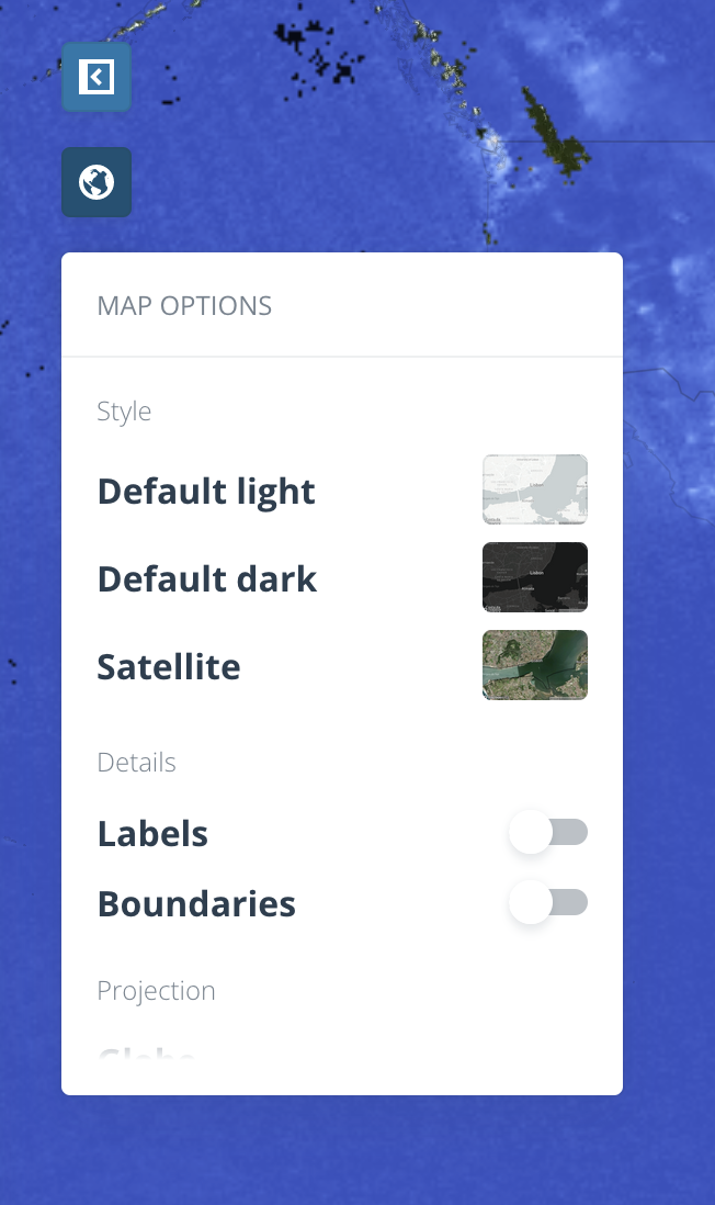
I figure this should be added to the map in the dataset exploration section, alongside other map controls:
Screenshot 2023-02-06 at 11 16 04

Overall design questions:

  • Is there a risk of confusion with the projection selector button? This planet icon pretty much already looks like a "basemap selector" icon, but maybe that's just me
  • What are the context layers we want to add?
    • Place labels:
      • Should the layer mentioned above appear on top of the raster layer(s) (I'm guessing yes, same as the existing boundaries)
      • Labels will require some styling in Mapbox Studio. Who's owning that? (I can, but we'd get better results from a designer :)
    • Do we want to add administrative boundaries beyond countries/adm0? (I reckon adm1 would be useful at the very least for US States)
    • Add a graticules layer? (would also need design in MB Studio)
    • Any use for a basic topography + bathymetry basemap?
      • For UI considerations: take into account that this would replace the satellite basemap, while the labels or graticules would be added on top of the satellite basemap.
  • Light/dark background variations? (impacts color of labels and boundaries too)
  • Should we also add this to the Analysis AoI selection map?

Screenshot 2023-02-06 at 11 14 28

As usual, I suggest we gather to define what's a good MVP for a first iteration and start building.

@ricardoduplos
Copy link
Contributor

ricardoduplos commented Feb 6, 2023

Capturing the solution @nerik and I discussed for the MVP:

  • The previous "Projections" action will become "Map Options", keeping the Globe icon for the button, but its scroll-able dropdown will be redesigned to harbor three groups of map-related options:
    • Style (exclusive option selection list):
      • Default light
      • Default dark
      • Satellite
    • Details (On/off togglable options list):
      • Labels
      • Boundaries
      • ...
    • Projection (exclusive option selection list)
      • Albers
      • Mercator
      • Globe
      • ...
  • Labels will be slightly styled to match the app typeface family ("Open Sans");
  • Other togglable options such as the Graticules, and maybe Fires and Watersheds, can be added under "Details" in the future;
  • It would be nice to include these Map Options on the analysis map as well, yes.

Some wireframes to illustrate this direction can be seen here:

@aboydnw
Copy link
Contributor

aboydnw commented Feb 27, 2023

Is this related to #405 ?

@nerik
Copy link
Contributor

nerik commented Mar 1, 2023

@aboydnw Same data, different feature (this one's only for reference, not for creating AoIs)

nerik pushed a commit that referenced this issue Mar 14, 2023
#442

This contains markup and styles for the Map Options dropdown. ~Ready to
be wired.~


https://user-images.githubusercontent.com/1583415/222201199-2b31ab16-8c3c-43c6-8c53-8a92913913aa.mov

<img width="326" alt="Screenshot 2023-02-08 at 10 54 57"
src="https://user-images.githubusercontent.com/1016701/217510514-e983cd4b-4769-48f6-a7a6-6bcdbadaabee.png">

Related to [#basemap](#442)
@danielfdsilva
Copy link
Collaborator

@nerik With #458 merged, should we consider this done? Is there some other things we want to track from here that merit a new issue?

@nerik
Copy link
Contributor

nerik commented Mar 17, 2023

@danielfdsilva Nope, marking this as done. Thanks for flagging.

Sign up for free to join this conversation on GitHub. Already have an account? Sign in to comment
Labels
None yet
Projects
None yet
Development

No branches or pull requests

5 participants