This is a titanium commonjs module for displaying large amounts of markers on the map. Markers that are close to each other are displayed as one annotation and can be unfolded by zooming in. It is also possible to customize clustered markers.
It uses a quadtree approach, so the complexity of clustering is linear. This makes it easy to deal with large amounts of data. The module also takes care of markers that are outside the boundaries of view.
Download the latest distribution ZIP-file and consult the Titanium Documentation on how install it, or simply use the gitTio CLI:
$ gittio install net.bican.mapannotationcluster
In tiapp.xml, add the ti.map module.
In alloy.js, require the map module:
Alloy.Globals.Map = require('ti.map');
Create your view:
<Alloy>
  <Window class="container" id="container">
    <View id="mapView" module="ti.map" onRegionchanged="regionChanged" method="createView"/>
  </Window>
</Alloy>
In your controller, define the module and the regionChanged function:
var CMA = require('ti-mapannotationcluster');

var regionChanged = function(e) {
  $.mapView.setAnnotations(CMA.fill({
    map : Alloy.Globals.Map,
    points : pts,
    latitude : e.latitude,
    longitude : e.longitude,
    latitudeDelta : e.latitudeDelta,
    longitudeDelta : e.longitudeDelta,
    singleAnnotationCaller : singleAnnotationCaller,
    multipleAnnotationCaller : multipleAnnotationCaller
  }));
};
singleAnnotationCaller and multipleAnnotationCaller are optional, but if you don't use them, all markers will look the same. So, also define them in the controller:
var singleAnnotationCaller = function(point) {
return Alloy.Globals.Map.createAnnotation({
pincolor : theMap.ANNOTATION_GREEN,
title : point.offset + ": " + point.latitude.toFixed(2) + "," + point.longitude.toFixed(2),
latitude : point.latitude,
longitude : point.longitude,
});
return point;
};
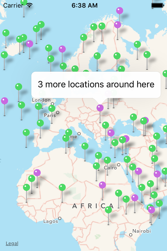
var multipleAnnotationCaller = function(point, annotations) {
return Alloy.Globals.Map.createAnnotation({
pincolor : theMap.ANNOTATION_PURPLE,
title : annotations.length + " more locations around here",
latitude : point.latitude,
longitude : point.longitude,
});
return point;
};
The point argument is the object that points to latitude and longitude of the location, and the annotations argument is the array of markers that are represented by this annotation.