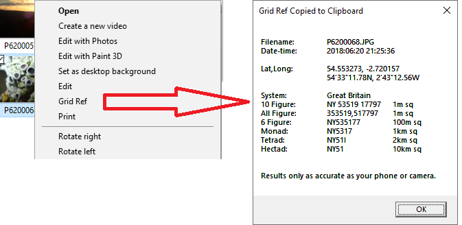
This tool displays a GB or Irish Grid Reference for a JPG file in Windows, if the photo has suitable GPS information. The Grid Reference is also copied to the clipboard, ready for pasting into a recording spreadsheet or website.
- Example GB grid reference:
NY 27332 33320, copied to the clipboard asNY2733233320. - Example Irish grid reference:
J 34386 74590, copied to the clipboard asJ3438674590. - Latitude, Longitude and other details such as tetrad are also listed.
The accuracy of the grid reference is primarily determined by the accuracy of the GPS reading in your phone or camera.
In many cases it may be best to express as a 6 figure grid reference eg NY273333 ie by removing the last two digits of each group.
- Once the tool is installed, right-click on a photo in Windows Explorer and select Grid Ref.
- If the Shift key is held down, then Eastings and Northings are found instead, eg
327332,533320 - If the Control key is held down, the location is shown in the default browser at streetmap.co.uk instead (only works in GB)
- To use the tool download and save PhotoGridRef.exe - or from here
- Save
PhotoGridRef.exeon your computer. - Double-click to install the context menu handler.
- After that, right-clicking on an image file will include Grid Ref on the context menu; click on that; if the image contains GPS info, the grid reference is displayed and copied to the clipboard.
- To uninstall, hold down Shift when right-clicking on an image and select Uninstall Grid Ref;
or double-click again on
PhotoGridRef.exein Windows Explorer. - You can then delete the file
PhotoGridRef.exe - In Windows 7+ the Grid Ref context menu item may only disappear after a reboot
- Can be installed by non-admin users
- Should work in Windows 7+, both 32 bit and 64 systems
- Tested in Windows 7 and Windows 10 64 bit
- This repository is the source code of a Microsoft Visual Studio Community 2022 project
- Mayank Lahiri's easyexif: A tiny ISO-compliant C++ EXIF parsing library. Copyright (c) 2010-2015 Mayank Lahiri
- Jonathan Heathcote's OS Coord: A Simple OS Coordinate Transformation Library for C - with designated initializers removed
- Paul Dixon's GeoTools javascript coordinate transformations
- More info available on Roger Muggleton's page at http://www.carabus.co.uk/ll_ngr.html
- netalloy's map pin icon and ICO Convert
- Support worldwide Maidenhead Locator System eg using this perl code Ham::Locator
- Display found data in selectable form
- Add icon and about box to displayed window
- License (BSD-3-Clause) BSD. Free for personal and commercial use.
