![]()

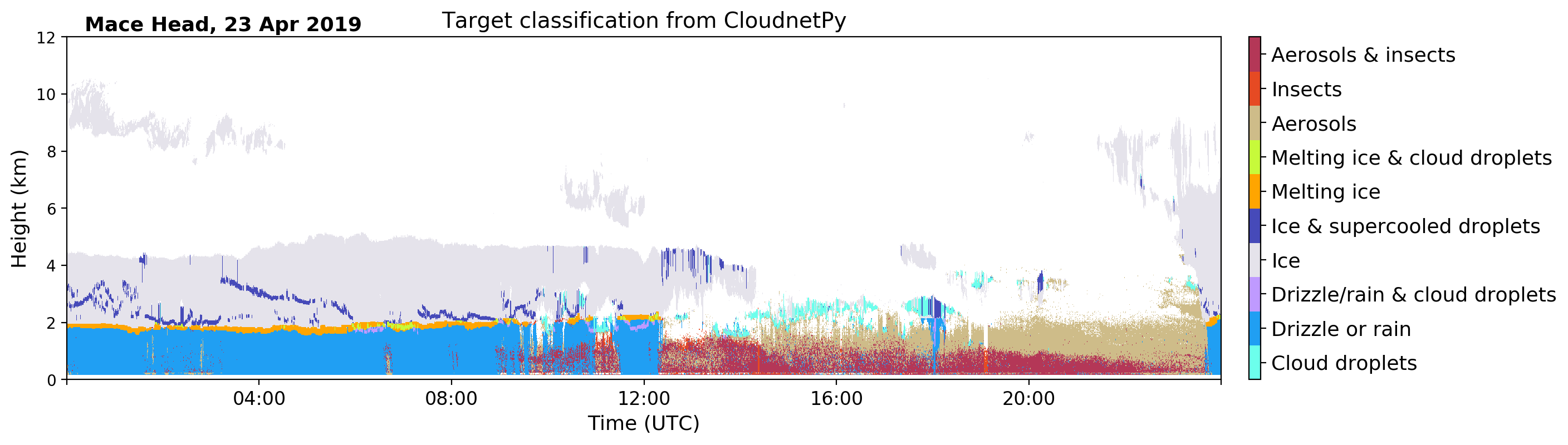
CloudnetPy is a Python software for producing vertical profiles of cloud properties from ground-based remote sensing measurements. The Cloudnet processing combines cloud radar, optical lidar, microwave radiometer and model data. Measurements and model data are brought into common grid and classified as ice, liquid, aerosol, insects, and so on. Then, geophysical products such as ice water content can be retrieved in the further processing steps. See Illingworth et. al. (2007) for more details about the concept.
CloudnetPy is a rewritten version of the original Cloudnet Matlab code. CloudnetPy features several revised methods, extensive documentation, and more.
- CloudnetPy documentation: https://cloudnetpy.readthedocs.io/en/latest/
- Cloudnet data portal: https://cloudnet.fmi.fi
$ python3 -m pip install cloudnetpy
$ git clone https://github.com/actris-cloudnet/cloudnetpy
$ cd cloudnetpy/
$ python3 -m venv venv
$ source venv/bin/activate
(venv) $ python3 -m pip install .
If you wish to acknowledge CloudnetPy in your publication, please cite:
Tukiainen et al., (2020). CloudnetPy: A Python package for processing cloud remote sensing data. Journal of Open Source Software, 5(53), 2123, https://doi.org/10.21105/joss.02123
We encourage you to contribute to CloudnetPy! Please check out the contribution guidelines about how to proceed.
MIT